Hamlets of North Nibley listed by Smyth, Atkyns, Rudder, Rudge (original spellings, but the list order rearranged to assist comparison
| SMYTH 1639 | ATKYNS 1712 | RUDDER 1779 | RUDGE 1803 |
| Churchend | Churchend 30 houses | Identical listing to Atkyns | Churchend |
| Swyney | Swinney 30 houses | Swinny | |
| The Green or Nybley Green | Great and Little Greens 20 houses | Great and Little Greens | |
| Fforthay | Fortoy 20 houses | Fortoy | |
| Horend | Whorend 20 houses | Whorend | |
| Mylend | Millend 12 houses | Millend | |
| Southend | Southend 5 houses | Southend | |
| Woodallend | Wooderlin 6 houses | Wooderlin | |
| Ffourd end | Smarts Green 20 houses | Smarts Green | |
| Birchley | Ridemisse 15 houses | Redemisse | |
| Snytend | Waterleigh 12 houses | Isle of Rhea | |
| 162 houses | 200 houses | 200 houses | 225 houses |
| 1000 inhabitants | 1000 inhabitants | 1000 inhabitants | 1000 inhabitants |
Of the above 11 names in each list, 8 persist recognisably from 1639-1803. Churchend led in size and importance from earliest times until early 19th century. Swinhay, apparently its numerical equal, must have been the most fragmented settlement: it was small by 1846, and is today but a farm and three cottages, to which shrinkage and re-naming have contributed. Warend too declined, clearly shown by the ‘scite of houses’ there on the Sale Catalogue of 1798. Birchley vanished. Forthay shrank, leaving house sites. The Green(s) changed form gradually until their demise in 1867. Millend boomed in the industrial phase. Fordend became Waterley, and Ridemisse still is obscure. Isle of Rhe is named from the Duke of Buckingham’s exploits off La Rochelle in 1627, is an interesting metamorphosis from Green-side cottage to small estate, Of all the persistent hamlets, Wooderlin was the insignificant outsider, later to take over as the village.
Of the 11 hamlets listed by Smyth in 1639, 3 have undeniably Saxon names, viz. Birchley, Forthay and Swinhay. Others have Saxon componants, and of the -end namesChurchend is assumed to be the major early settlement though the others may well be contemporary. Closer study of the three essentially Saxon-named hamlets has been rewarding.
Birchley
‘clearing among birch trees’. This is now represented by two fields of this name and confused earthworks in an adjoining field. Field-walking has produced sherds of coarse pottery, lime-gritted, dated C12-13 from molehills over the earthworks. Nearby are fields named Wilsley ‘personal name plus leah’. This was an extensive open field, still showing some strips on the Tithe Map of 1846, and aratral curves in the hedgerows now within it. This field has shown the only ridge-and-furrow found anywhere in Nibley parish to date as the ridges are approximately half the usual 8-10 yards across. The hamlet and field system thus occupied the remote eastern end of Waterley Bottom.
Forthay
‘the ford by an island in a marshy area’ does not accord with its topography today, though the hamlet resembles an island in a sea of woodland, and the Doverle brook is close at hand. The grouping is that of a village in miniature: four substantial farmhouses with their crofts have fronted ‘the green’ on its northern aspect while cottages and house platforms straggle along that part of its encircling road still called Back Lane. This deeply hollowed way is bordered by original woodland, shown by the presence of bluebells, dogs mercury and wood anemones among the coppiced trees. Some 30 metres to the NE is Pitt Court which had sub-manorial status, including a Court Baron still functioning in 1639, and which surely be related to this settlement.
see also Forthay
Swinhay
‘swine enclosure’, was at first deeply within Michaelwood. When clearance reached this point Swinhay Lane extended still further into the Chase, continuing to provide access for pannage, building materials, fuel and rough grazing. The settlement called Swinhay seems always to have been sizeable, decling only when industry caused a shift of population in the 18th Century. It equalled Churchend’s 30 houses, but the uncoordinated nature of the group is indicated by the distance of the meadow called Swinhay, some 600 metres from the home farmstead, with its discrete scatter of cottages. Small irregular fields closely surround Swinhay Farm, with its ring fence feature, confirming its origins as an outlying forest enclosure.
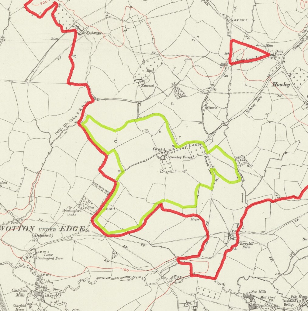
reproduced with the permission of the National Library of Scotland
The green line indicates the boundary of Swinhay Farm at the time of the 1848 Tithe Approtionment. It was owned by Richard Wallington, and leased to William Gillman.
The farmhouse was demolished in the 1990s, and the land is now occupied by Swinhay House.
The red line outlines Swinhay Meadow.
